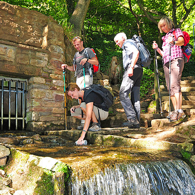
• de
  • en
Go to home

Menu

  • Home
  • The North-Eifel
    • Back
    • District of Euskirchen
    • Town of Bad Münstereifel
    • Municipality of Blankenheim
    • Municipality of Dahlem
    • District Town of Euskirchen
    • Municipality of Hellenthal
    • Municipality of Kall
    • Town of Mechernich
    • Municipality of Nettersheim
    • Municipality of Schleiden
    • Municipality of Weilerswist
    • Town of Zülpich
  • Activities
    • Back
    • Hiking
      • Back
      • Overview of the Hiking paradise in the North Eifel
        • Back
        • Eifel Traces (EifelSpuren)
        • Eifel Loops (EifelSchleifen)
        • Eifelsteig
        • Eifel National Park
        • Roman Canal Trail
        • AhrSteig
        • Wilderness Trail
        • Main trails of the Eifel Association
        • Jacobs Pilgrim Path Cologne/Bonn - Trier - Schengen
        • Rur-Olef-Route
        • Castle Route
        • Eifel Source Path
        • Schleiden Trail Network
        • Hiking trails for families with children
        • Eifel Platform Trail
      • Packaged deals
        • Back
        • Consultation and booking office
        • Roman Canal Trail
        • EifelSteig over short distances
        • Rur - Olef trail
        • On Old Paths through the Eifel
        • Wilderness & Wellness
        • Eifel Source Path
        • Eifel Traces
        • Flourish in the Eifel
        • [Translate to Englisch:] EifelSpuren kulinarisch
      • Hike buses
      • Cycle and hike train stations
      • Guided hikes
      • Online hiking tour planner
      • Events
      • Brochures and maps about hiking in the northern Eifel
    • Cycling
      • Back
      • Overview cycling paths
        • Back
        • Eifel Heights Route
        • Eifel National Park
        • Valley routes
        • Moated Castles Route
        • Kyll Cycle Route
        • Ahr Cycle Trail
        • Erft Cycle Path
        • Three River Tour
        • Mountain bike routes
      • Day and multi day packages
        • Back
        • Erft Cycle Path
        • Eifel Heights Route
        • Moated Castles Route
      • More tour suggestions
      • Cycle and hike train stations
      • Bicycle Tour Planner
      • Rentals and service station
      • Events
      • Brochures & Maps
    • Experience Nature
      • Back
      • Eifel National Park
        • Back
        • Wilderness Trail
        • Barrier free Nature Adventure Area "Wild Kermeter" and "Wild Path"
        • Themed tours
        • Walking with rangers
        • Individual tours with a forest guide
        • Cycling
        • National Park for families, children, and youth
        • Birdwatching
        • Deer observation
        • On tour with the "Zoom"
        • On tour by ship
        • Carriage ride
        • National Park Centre Eifel
        • National Park Gates in the Eifel
      • North Eifel Nature Park
        • Back
        • Eifel expeditions
        • Eifel Views
        • Network of Nature Centres
      • Rhineland Nature Park
        • Back
        • Experience nature
        • Experience Culture
        • Tour Tips
      • Exclusive Nature adventure
      • Moments in nature
      • Events
    • Eifel Trekking
    • Wildlife park
      • Back
      • Hellenthal Birds of Prey Compound
      • Rhineland Wildlife Park
    • Star Park Eifel National Park
      • Back
      • Astronomy Workshop "Stars without borders"
      • Adventure region day and night
        • Back
        • Day trips
        • Short vacation
      • host
      • Events
      • The downside of the light
      • Our goal
    • Health
      • Back
      • Barefoot- and Generation-park
      • Vital Eifel
    • [Translate to Englisch:] Freizeit
      • Back
      • Aviation
      • Golf
        • Back
        • Golf
        • [Translate to Englisch:] Bauern-, Mini- & Disc Golf
      • Obstacle course
      • High ropes course
      • Go-kart track
      • The Northeifel on horseback
      • Nordic walking
      • Rope sliding Park
      • Winter sports
        • Back
        • Weisser Stein
      • Further leisure activities
  • Culture time
    • Back
    • Vogelsang IP
    • Archaeological Monuments
      • Back
      • Nettersheim Archaeological Landscape Park
      • North Eifel Archaeo Region
      • Cacus caves
      • Roman Eifel waterways
      • Limekiln in Iversheim
      • Blankenheim Roman Villa
      • Roman Road Adventure Region
    • Astronomy
      • Back
      • Astronomy Workshop
      • Stockert Astropeiler
      • Effelsberg radio telescope
    • Exhibitions and theme parks
      • Back
      • Ardenne Cultural Boulevard
      • Exhibition "Weather, Climate, People"
      • Underground atomic bunker of the NRW Federal state government
      • Former bunker of the NRW Federal Central Bank
      • Eifalia Butterfly garden
      • Rupperath Hand Weaving Museum
      • Groß-Vernich Crafts and Local History Museum
      • Eifel Art Forum
      • Greven Kunsthof
      • "kuba" Nettersheim Culture railway station
      • Nettersheim literature house
      • National Park Gates
      • [Translate to Englisch:] Nationalpark-Zentrum Eifel
      • Eifel Nature Centre
      • Nature and Landscape Museum
    • Castles, Monasteries, Churches and chapels
      • Back
      • Bruder-Klaus Kapelle
      • Bad Münstereifel Castle
      • Blankenheim Castle
      • Langendorf Castle
      • Reifferscheid Castle
      • Satzvey castle
      • Hardtburg
      • Steinfeld Monastery
      • Kronenburg
      • Zülpich Regional Castle
      • Schleiden Castle Church
      • Swist Tower
      • Wildenburg Castle
    • Historical town centres
      • Back
      • Bad Münstereifel
      • Blankenheim
      • Kommern
      • Kronenburg
      • Olef
      • Reifferscheid
    • Museums
      • Back
      • Mechernich mining museum
      • Blankenheim Eifel Museum
      • Visitors’ mine "Grube Wohlfahrt"
      • Hasenberghof
      • LVR Kommern Open-Air Heritage Museum
      • LVR Industrial Museum - Müller cloth factory
      • Zülpich Roman Thermals- Museum of Bathing Culture
      • Red Cross Museum at Vogelsang iP
      • Euskirchen Town Museum
      • Swan Pharmacy Museum
    • Zülpich Lake Park
    • Events
  • Family Time
    • Back
    • Outdoors
      • Back
      • Archaeological Landscape Park
      • Astronomy
        • Back
        • Effelsberg radio telescope
        • Stockert Astropeiler
        • Astronomy Workshop
      • Satzvey castle
      • Free time
        • Back
        • Making a bow and archery
        • Eifel gate Adventure world
        • Aviation
        • Rope sliding Park
        • Obstacle course
        • High ropes course
        • Go-kart track
        • Zülpich Lake Park
      • Museums
        • Back
        • LVR Kommern Open-Air Heritage Museum
        • Eifel Nature Centre
      • Fun, sports & recreation in the water
      • Hiking trails for families with children
        • Back
        • [Translate to Englisch:] EifelSchleifen
        • [Translate to Englisch:] EifelSpuren
        • Cacus caves
        • Eifel National Park
        • Barrier free Nature Adventure Area "Wild Kermeter" and "Wild Path"
      • Wildlife park
        • Back
        • Hellenthal Birds of Prey Compound
        • Rhineland Wildlife Park
    • Indoors
      • Back
      • Exhibitions and worlds of experience
        • Back
        • Ardenne Cultural Boulevard
        • Eifalia Butterfly garden
        • National Park Gates
        • Eifel Nature Centre
      • Indoor leisure activities
        • Back
        • Making a bow and archery
        • Eifel gate Adventure world
        • Hugodrom
      • Museums
        • Back
        • Mechernich mining museum
        • Eifel Museum
        • Visitors’ mine "Grube Wohlfahrt"
        • LVR Industrial Museum - Müller cloth factory
        • Zülpich Roman Thermals- Museum of Bathing Culture
        • Red Cross Museum at Vogelsang iP
        • Euskirchen Town Museum
        • Swan Pharmacy Museum
      • Fun, sports & recreation in the water
    • Satzvey castle
    • Holiday on a farm
    • Events
  • Events
    • Back
    • Events calendar
  • Hospitality
    • Back
    • Accommodation overview
    • Book accommodation online
    • North Eifel Guest magazine
    • Package deals
      • Back
      • Advice and Booking Bureau
    • Camping and caravan
    • Group accommodations
    • Eifel Trekking
    • Gastronomy
    • Relaxing outside
    • Shopping Experience
      • Back
      • Bad Münstereifel
      • Shopping in Euskirchen
    • Farm shops and markets
    • Quality
  • Good to know
    • Back
    • Sustainability
    • Service
      • Back
      • Contacts
        • Back
        • Advice and booking office
      • Tourist information
      • Getting there
      • E- Mobility
      • Guest pass
      • Training, Internship and Jobs
      • Procurement Conditions
      • Photo credits
    • Contact
    • Timetable information
    • Press
    • Partners
      • Back
      • Mission statement
      • Landlord-login
    • Newsletter
    • Brochures
    • Cards
    • Imprint
    • Data protection
  • Weather
  • Hiking Routes
  • Unterkunft suchen und buchen

  • Interactive Map
  • Social Media

Search accommodation

Search

  1. Home
  2. Activities
  3. Experience Nature
  4. Water

Water

Numerous lakes, rivers, and reservoirs make the region a unique living and recreation area for people, animals, and plants. Be enchanted by the beauty of nature in the North Eifel.

Wasserverband Eifel-Rur

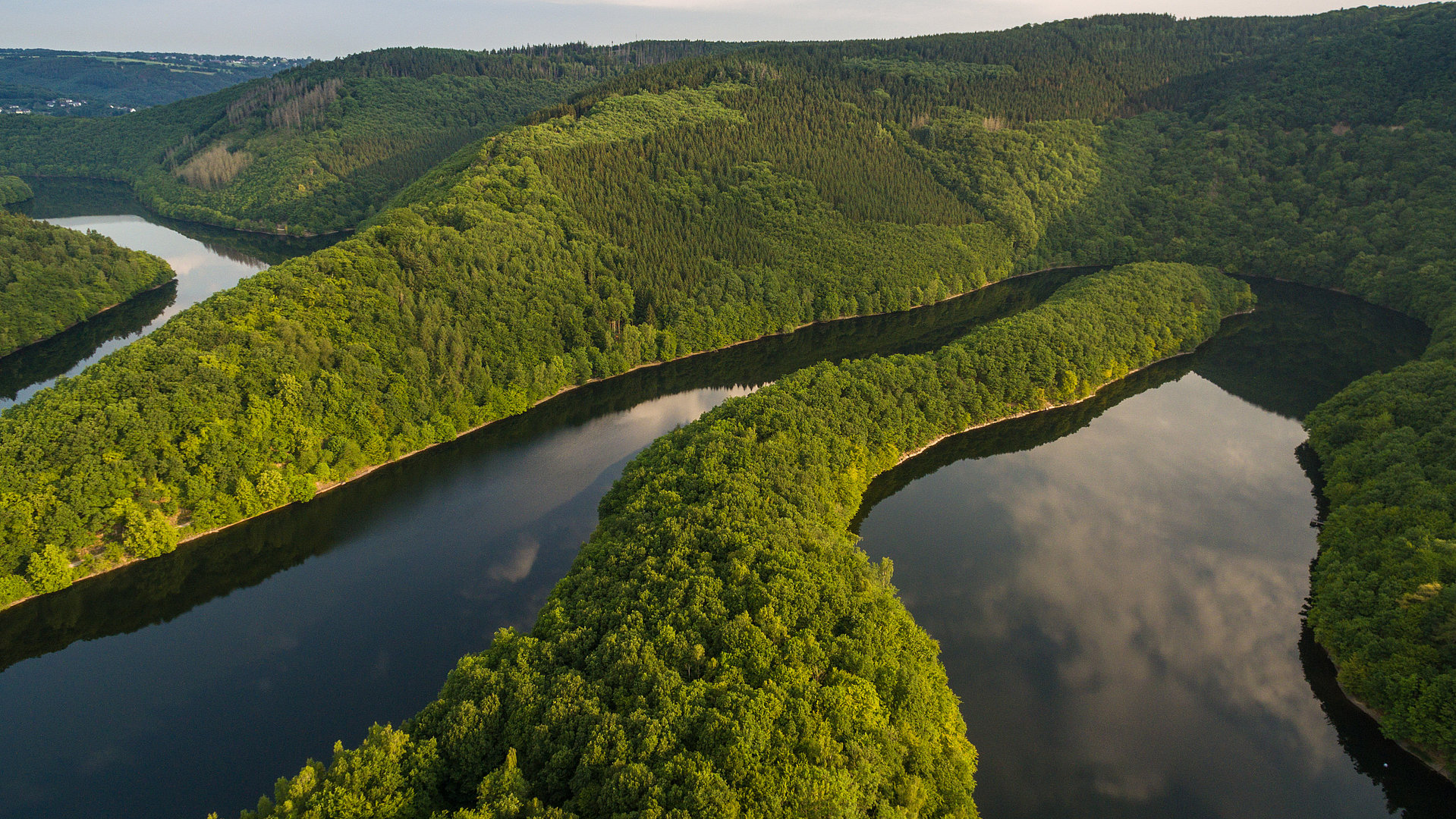
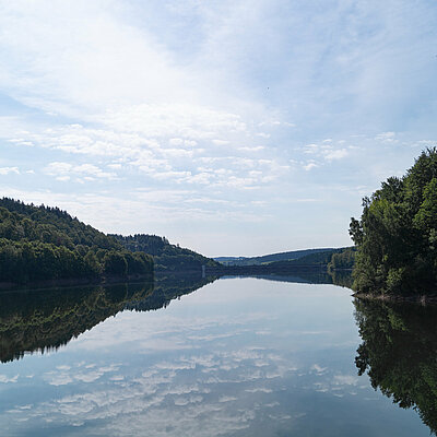
"Urfttalsperre" (Urft reservoir/dam)

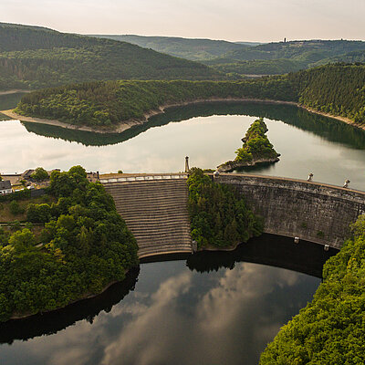
Around the turn of the century (1900 - 1905), the dam was built at the lower reaches of the river Urft to reduce the risk of flooding, to balance the irregular water supply, and to improve the water runoff during times with low precipitation. At the time of completion and commissioning of the reservoir, the Urfttalsperre was the largest dam in Europe. Today, it is operated in conjunction with the Oleftalsperre and the Rurtalsperre Schwammenauel. The large scale dam is 58 meters high and 50.5 meters wide at the base and it holds a volume of 45,5 million cubic meters. It is curved to the water side and 226 meters long. The dam is sealed with a 2.5cm thick cement plaster on the water side. Vertical drainage pipes consisting of clay, and 60 mm in diameter are installed at a distance of 2.5 meters and divert penetrating water. A tour of the dam is possible by appointment!

"Steinbachtalsperre" (Steinbach reservoir/dam)

The dam was built in 1935 under pressure of the Euskirchen cloth factory and it was expanded and renovated to become the largest artificial water basin in the Eifel in 1990. The open air pool consists of a large toddler pool, a 1,400 square meter non-swimmers pool, and a 7,500 square meter pool for advanced swimmers. A giant slide, a five-meter diving tower with three jumping platforms, a beach volleyball court, and a children’s playground guarantee fun for everyone.  The in-house brewery and beer garden invites to stop and rest. The “Lehrpfad” hiking trail is equipped with natural history display boards.


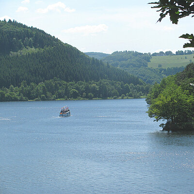
"Oleftalsperre" (Olef reservoir/dam)

Between 1954 and 1959 the the 20 million cubic meter drinking water reservoir was built in the beautiful forest near Hellenthal where the picturesque lake Olef is located. Its pillar design is still unique in Germany. A 13.5km long path surrounds lake Olef which is great for walkers, hikers, and cyclists. The enormous dam impresses young and old visitors alike. A tour of the dam is possible by appointment. Please register at the “Wasserverband Eifel- Rur under the following phone number. 02482.85200

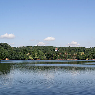
"Freilinger See" (Lake Freilingen)

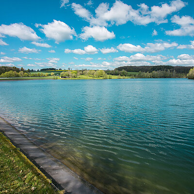
Lake Freilingen is located in a valley surrounded by vast forests and meadows. The natural charm of this forest lake is due to large open sunbathing lawns and clusters of shrubs. The reservoir exists since 1976 and it is supplied with fresh spring water. It was built for the purpose of retaining rain water and as a tourism attraction. The water surface of the lake is 11 hectares with a catchment area of 5 square kilometres. The dam is 25m high, 115m wide at the base and 9.5m wide at he top, and approximately 500m long. The lake is 10m deep on its deepest spot, and it holds a volume of 0.73 million cubic meters. There are extensive possibilities for swimming and water sports in the lake. Several hiking trails, such as the AhrSteig pass the lake. Camping is possible at an adjacent campsite. 


Lake Kronenburg

In addition to the surrounding National Park landscape of the upper Kyll valley, the area also offers a variety of recreational and leisure possibilities. The dam was built from 1973-1976 and is used as a retention basin for the annual flood of the Kyll, which mainly threatened the floodplain in the spring. The retention basin consists of a main blocking system and an auxiliary dam, the main barrier is located about 200m west of Kronenburghütte and the auxiliary dam is located 300m below the junction of the Taubkyll into the Kyll. The total volume is 2.7 million cubic meters, 2.1 million cubic meters are held in the main holding area and 0.6 cubic meters are held in the auxiliary dam. 

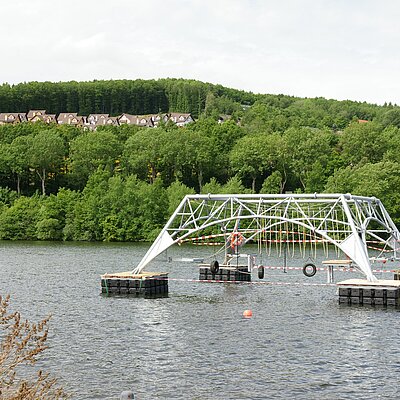
"Wassersportsee Zülpich" (water sports lake Zülpich) and lake Neffel

The Wassersportsee and lake Neffel are relicts from the mining era that took place in the area around Zülpich in the fifties and sixties. These two mining lakes and the slag heap near Langendorf are evidence of the massive landscape change. Of these, the Wassersportsee is the most visited attraction for water sports enthusiasts and those that enjoy open air swimming and sunbathing. For the “Landesgartenschau 2014 in Zülpich” (State Garden Show), the Wassersportsee was cosmetically improved and since then it offers opportunities for water sports again. 
Lake Neffel has become a home for protected animals and plant species.

Erft

The river Erft is a nearly 107km long left tributary of the Rhine. The formerly well stocked fishing river has its origin at the north-west border of the Eifel , belonging to the Ahr mountain region. Its source is located beneath the Himberg at 550m above sea level near Nettersheim-Holzmühlheim. From there the Erft initially flows in northeastern direction and later in predominantly northern direction through Euskirchen and Weilerswist. A well developed cycle path runs parallel to the Erft. The 110km long Erft cycle path runs from the source of the Erft to where it flows into the Rhine near Neuss.

Urft

The Urft is a 50.2km long right tributary of the Rur. It springs near the Dahlem Binz Airfield by Schmidtheim and flows through Nettersheim, Kall, and Gemünd and it flows into the Rursee(lakeRur) near Rurberg. Before it flows into the Urft, it is held by the 14km long Urft reservoir. The main tributaries of the Urft are the streams Gensbach, Gillesbach, Kuttenbach, Kallbach, and the river Olef. The Urft valley cycle path runs parallel to the Urft.

Olef

The river Olef is a 27.9km long right tributary of the Urft. Its source is in Zitterwald, approx. 2.2km south west of Hollerath at level of 639m above sea level, close to the border to Belgium. From there, it initially flows in northwest direction, passing the border and flows through the Dreiherren forest. After a distance of approximately 1.8km it reaches the border again before it then flows to the east in a wide bend. In the following section, the Olef is held in a reservoir before it reaches Hellenthal. In Gemünd, the Olef flows at 334m left tributary into the Urft. The Olef valley cycling path runs parallel to the Olef. 

Ahr

The Ahr has its source in Blankenheim in the basement of a half-timbered house at the foot of Blankenheim Castle. The spring is surrounded by quarry stone and it lies 470m above sea level. In North Rhine -Westphalia, the Ahr flows parallel to the Federal highway B258 through  the natural protected area of the Ahr valley to the town Ahrdorf in the municipality of Blankenheim (Ahr). Tributaries are the streams Lamperzbach and Ahbach. Behind the border to Rhineland-Palatinate, it flows into the northeast direction. Via Antweiler, Schuld, Altenahr, Dernau, and Bad Neuenahr-Ahrweiler it reaches the neighbourhood of Kripp in Remagen where it flows into the Rhine. The Ahr confluence lies in Sinzig, approx. 50m above sea level. The confluence is under protection because it is the only natural confluence into the Rhine. The Ahr cycle path and AhrSteig run parallel to the Ahr. 

Nah dran. Weit weg!<br/>Die <strong>Nordeifel</strong>

Go to the YouTube ChannelGo to the Instagram ProfileGo to the Facebook Page

Nordeifel Tourismus GmbH

  • Sustainability
  • Service
  • Contact
  • Timetable information
  • Press
  • Imprint
  • Data protection
  • Newsletter
  • Brochures

Publisher

Nordeifel Tourismus GmbH
Bahnhofstraße 13 · 53925 Kall
Tel. 02441. 99457-0 · Fax 02441. 99457-29
info(at)nordeifel-tourismus(dot)de
www.nordeifel-tourismus.de

Logo Kreissparkasse Euskirchen
Logo Eifel
Logo Exzellenzinitiative

© Copyright 2023 | Nordeifel Tourismus GmbH